SGI Unveils Interactive Web Application To Bolster Wildlife Conservation Work
Today, the Sage Grouse Initiative is unveiling a new tool to catalyze and improve habitat conservation efforts across the western United States. The free SGI Interactive Web Application presents cutting-edge geospatial data covering 100 million acres.
Conservation Working For Ranchers And Sage Grouse In The West
February 18, 2016
Webinar: Strategic Cheatgrass Management in Sagebrush Ecosystems
February 29, 2016
New tool turns science into actions that benefit working lands and wildlife
Today, the Sage Grouse Initiative, led by USDA’s Natural Resource Conservation Service, is unveiling a new tool to catalyze and improve habitat conservation efforts across the western United States. The SGI Interactive Web Application is free and available to the public, presenting cutting-edge geospatial data covering 100 million acres. The SGI science team has developed an easy-to-use web application that helps visualize, distribute, and interact with information about the sagebrush-steppe ecosystem.
Developed in partnership with the University of Montana and others, SGI used Google Earth Engine to build a new interactive online map that, for the first time, combines layers of related data to better target invasive species damaging habitat and rangeland in 11 states. The new app currently allows farmers, ranchers, conservationists and other partners to analyze data on the encroachment of conifers and cheatgrass on key rangeland. The SGI science team will continue to add more layers to the map as they are developed—such as data on fence collisions and subdivision risk—to help address threats to sage grouse and the 350+ species that depend on healthy sagebrush-steppe habitat.
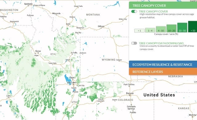
The goal is to put information directly into the hands of the resource managers who need it. The layers available now include high-resolution tree canopy cover and ecosystem resilience and resistance index data across the range of sage grouse. All data can be easily downloaded, allowing custom analysis to make the most difference for working lands and wildlife.
“By putting cutting-edge products at the fingertips of practitioners and landowners, it helps us more quickly turn science and technology into targeted action on-the-ground,” said Jeremy Maestas, NRCS regional biologist.
Brady Allred, a rangeland specialist with University of Montana who developed the new web app, said he is excited that SGI will continue to build on the tool over time.
“Since we focused on such a large area, we are able to provide the big picture—it’s a better view of what’s occurring across boundaries, so that each effort supports the greater goal and helps reduce future threats,” Allred said.
The newly created tree canopy cover layer, developed by Michael Falkowski at Colorado State University, shows where conifers are degrading critical habitat on the range. SGI and partners can use this information to target projects that improve sage grouse habitat by removing invading conifers when the trees are young and more easily eradicated. Another layer now available provides an index of ecosystem resilience and resistance to cheatgrass based on underlying soil temperature and moisture, which will help resource managers protect and restore crucial sagebrush ecosystems.
All of the information can be easily visualized on top of physical maps or the latest satellite imagery. Users can quickly identify and compare areas of concern, evaluating potential restoration or prevention opportunities. Data can be imported from the web application directly into GIS software, which allows the public to customize the information for land management or conservation purposes. Data for individual counties can be downloaded using these simple instructions.
The interactive web application aligns with the Sage Grouse Initiative 2.0 investment strategy, a four-year $211 million effort to help conserve sagebrush habitats in 11 Western states.
“Our Sage Grouse Initiative 2.0 investment strategy has science at its core, and this new website brings crucial information to conservation planners to enable them to craft the best plan for specific locations,” NRCS Chief Jason Weller explained. “Not only will this be pivotal for NRCS staff, but for our partners as well.”
Check out the SGI Interactive Web Application here.
Read instructions on how to download the data here.
Read the USDA Blog by SGI Coordinator, Thad Heater here.
See the latest conservation results in NRCS’ Greater Sage-Grouse Scorecard.


