Publication Alert
Publication Alert: The Invasion Severity Index
The Invasion Severity Index map and web application improves management of invasive annual grasses in the sagebrush biome.

Upland Bird Leks: The Wildest Dance Floors On Earth
April 11, 2026
Beavers Take Center Stage In Movies And On Western Ranches
April 17, 2026
MAPS AND WEB APPLICATION DESIGNED TO SUPPORT INVASIVE ANNUAL GRASS MANAGEMENT ACROSS THE SAGEBRUSH BIOME
Invasive annual grasses (IAG) pose one of the most significant and rapidly expanding threats to rangeland health across the western United States. These exotic grasses include cheatgrass, medusahead, and ventenata, and when they overtake rangelands, they alter fire regimes, reduce habitat quality, and diminish long-term productivity.
Developing effective management strategies and treatment prescriptions requires an understanding of the degree of invasion in an ecological context, including site potential, competitive balance with perennial grasses and forbs, and overall productivity.
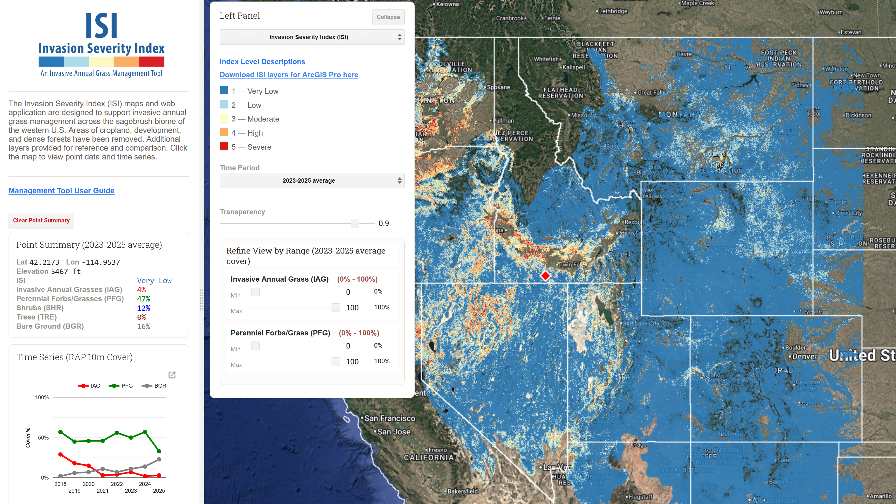
The Invasion Severity Index (ISI) maps and web app provide a simple, interactive platform to help conservation planners and land managers prioritize and plan invasive annual grass treatments across the sagebrush biome. Using cutting-edge Rangeland Analysis Platform (RAP) 10-meter resolution data, ISI maps leverage the latest advances in remote sensing.
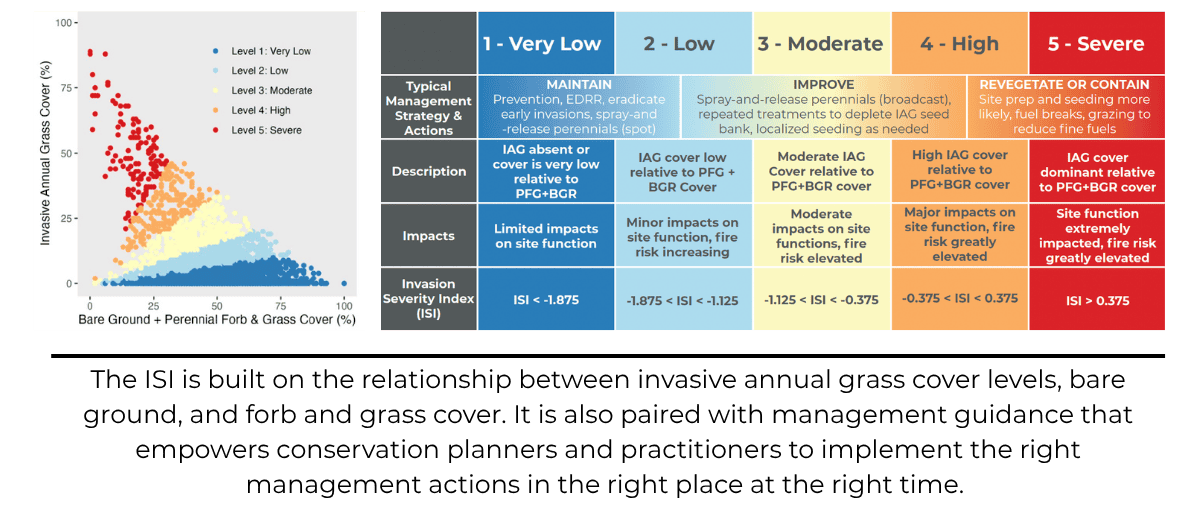
The ISI assesses the severity of annual grass invasion relative to perennial forb and grass cover and bare ground, providing an ecologically grounded framework for prioritizing management and aligning treatment techniques with site resilience and recovery potential. Other reference layers and features allow users to understand landscape context, consider trends through time, visualize specific vegetative thresholds, and generate time series charts.
Depicted in five invasion levels linked to specific management strategies and actions, the ISI provides an ecologically grounded framework for prioritizing management and aligning treatment techniques with site resilience and recovery potential. The maps and web app are not intended to serve as a one-stop solution, but rather as one tool among many available to conservation planners and partners.
The Invasion Severity Index
Abstract: The Invasion Severity Index (ISI) maps and web app provide a simple, interactive platform to help conservation planners and land managers prioritize and plan invasive annual grass treatments across the sagebrush biome.
Using cutting-edge Rangeland Analysis Platform (RAP) 10-meter resolution data, ISI maps depict five invasion levels linked to specific management strategies and actions. The ISI assesses the severity of annual grass invasion relative to perennial forb and grass cover and bare ground, providing an ecologically grounded framework for prioritizing management and aligning treatment techniques with site resilience and recovery potential. Other reference layers and features allow users to understand landscape context, consider trends through time, visualize specific vegetative thresholds, and generate time series charts.
Citation: Tilley, D., Maestas, J., Smith, J., Mueller, K., Morford, S. and D. Naugle. 2026. Invasion Severity Index: Maps and Web App to Support Strategic Invasive Annual Grass Management.
Permanent URL: https://www.wlfw.org/invasion-severity-index
Acknowledgements: WLFW thanks the following individuals for helpful testing and feedback during development: Brian Mealor (University of Wyoming), Megan Creutzberg (The Nature Conservancy), John Hartung, and Blaise Allen (NRCS Wyoming), and Chad Boyd and Dustin Johnson (Eastern Oregon Agricultural Research Center).