Invasion Severity Index
The Invasion Severity Index (ISI) online mapping application helps practitioners plan invasive annual grass management efforts across the sagebrush biome.

In South Dakota, A Young Couple Focuses on Their Ranch’s Primary Asset: Grass
March 19, 2026
Upland Bird Leks: The Wildest Dance Floors On Earth
April 11, 2026
Supporting Invasive Annual Grass Management Across the Sagebrush Biome
Invasive annual grasses (IAG) pose one of the most significant and rapidly expanding threats to rangeland health across the western United States. These exotic grasses include cheatgrass, medusahead, and ventenata, and when they overtake rangelands, they alter fire regimes, reduce habitat quality, and diminish long-term productivity.
Developing effective management strategies and treatment prescriptions requires an understanding of the degree of invasion in an ecological context, including site potential, competitive balance with perennial grasses and forbs, and overall productivity.
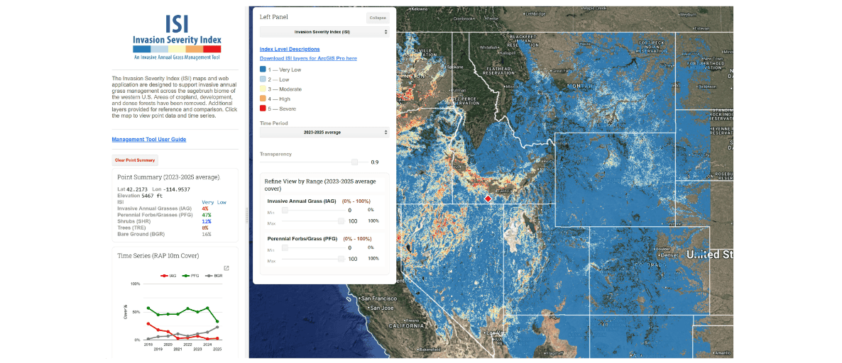
The Invasion Severity Index (ISI) maps and web app provide a simple, interactive platform to help conservation planners and land managers prioritize and plan invasive annual grass treatments across the sagebrush biome. Using cutting-edge Rangeland Analysis Platform (RAP) 10-meter resolution data, ISI maps depict five invasion levels linked to specific management strategies and actions.
The ISI assesses the severity of annual grass invasion relative to perennial forb and grass cover and bare ground, providing an ecologically grounded framework for prioritizing management and aligning treatment techniques with site resilience and recovery potential. Other reference layers and features allow users to understand landscape context, consider trends through time, visualize specific vegetative thresholds, and generate time series charts.
Managing for Site Resilience
Effective, long-term weed management doesn’t just require managing against something; it also requires managing for something. Percent cover of invasive species is a useful metric for describing the extent of annual grass presence; however, it does not provide sufficient information to make specific management decisions.
Equally important is the balance between invasive annual grasses and desired perennial grasses because perennial grasses play a critical ecological role by capturing soil moisture, nutrients, light, and belowground space that invasive annual grasses require to re-establish each year. Sites with abundant perennial grasses are more resistant to invasion following disturbance and more likely to respond favorably to management or restoration treatments.
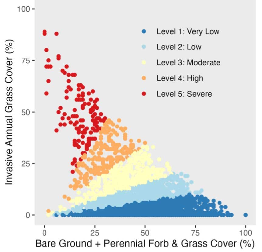
Invasion states show a ratio of percent cover of invasive annual grasses to perennial forbs and grasses plus bare ground cover. Each pixel indicates the cover ratio value of an actual site. Data points were derived from 3,145 random pixels of natural vegetation where tree cover was <20%.
Recent advances in remote sensing—specifically the availability of the Rangeland Analysis Platform (RAP) 10-meter resolution data—provide new opportunities to visualize and assess the relationship between various plant functional groups at management-relevant scales. For the first time, RAP 10-m provides an invasive annual grass (IAG) functional group layer that estimates the percent cover of the ten most common invasive annual grass species in the western U.S. This allows invasive annual grass cover specifically to be compared to desired perennials and other indicators to depict invasion severity and recovery potential at relatively fine scales through time.
One Tool Among Many
The Invasion Severity Index (ISI) maps and web app leverages this new spatial data and provides a suite of products to support invasive annual grass project planning and decision-making across the sagebrush biome. Depicted in five invasion levels linked to specific management strategies and actions, the ISI provides an ecologically grounded framework for prioritizing management and aligning treatment techniques with site resilience and recovery potential. The maps and web app are not intended to serve as a one-stop solution, but rather as one tool among many available to conservation planners and partners.
They are most effective when used in conjunction with complementary planning frameworks such as the Sagebrush Conservation Design, Threat-Based Strategic Conservation, and when informed by local expertise and relevant datasets. The University of Wyoming’s IMAGINE partnership provides in-depth training and resources that can help users increase their knowledge of how to plan effective treatments, and this web app is designed to be used with their guiding principles in mind.
For the first time we can see where and how invasive annual grasses exist within the broader sagebrush ecosystem, allowing us to pinpoint where annual grass management efforts have the greatest chance for success. ~ Derek Tilley, WLFW Sagebrush Technical Transfer Specialist.
Analysis Coupled with Management-Decision Guidance
ISI maps are presented in five levels linked directly to typical management strategies and actions. These categories simplify complex environmental conditions into meaningful levels designed to help practitioners with treatment delineation, selecting appropriate actions, setting site-appropriate goals and expectations, and tracking change through time.
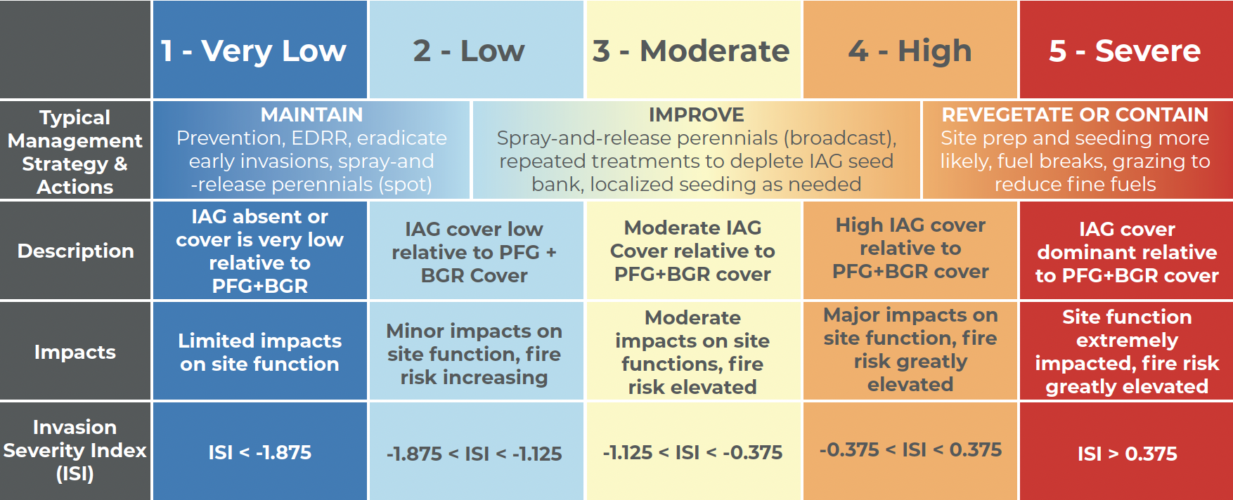
The category breaks do not represent fixed ecological thresholds; rather, they are intentionally simplified divisions that help managers interpret patterns on the landscape and prioritize actions in a consistent, transparent way. Accordingly, the associated management strategies and actions are intended as suggestions, not rigid prescriptions, and should be adapted to site-specific conditions, management objectives, and available resources. Use the maps with best professional expertise and field observations to adjust as needed.
Because the levels depict invasion severity as it relates to management strategies, some areas may be categorized differently than one might expect. For example, a site may have >30% IAG cover but still be categorized as a moderate ISI provided it also has a relatively high (~50%) perennial forb and grass cover. In this case, the exact cover of invasive annuals is less important than the proportion of perennials in determining what management action would likely be applied on the ground. Again, conservation planners and land managers should always use local expertise and knowledge to help inform actual prescriptions.