
Western Working Lands Snapshot | Kīpuka in the Sagebrush Biome
September 25, 2025
Grit, Grass and Gated Pipe Help A Wyoming Ranch Thrive
December 8, 2025America's Last Great Grasslands
Grasslands are among the most imperiled ecosystems on earth.
The U.S. is home to two of the largest remaining intact grasslands.


Nebraska Sandhills
The #1 most intact temperate grassland on earth.
The Sandhills grasslands are as big as Massachusetts and New Jersey combined, covering 19,000 square miles. These wide-open grasslands are home to deer, antelope and prairie chickens, as well as 670 different types of native plants. They are a key stopover for millions of birds migrating along North America’s Central Flyway. Photo: Dillon Fogarty

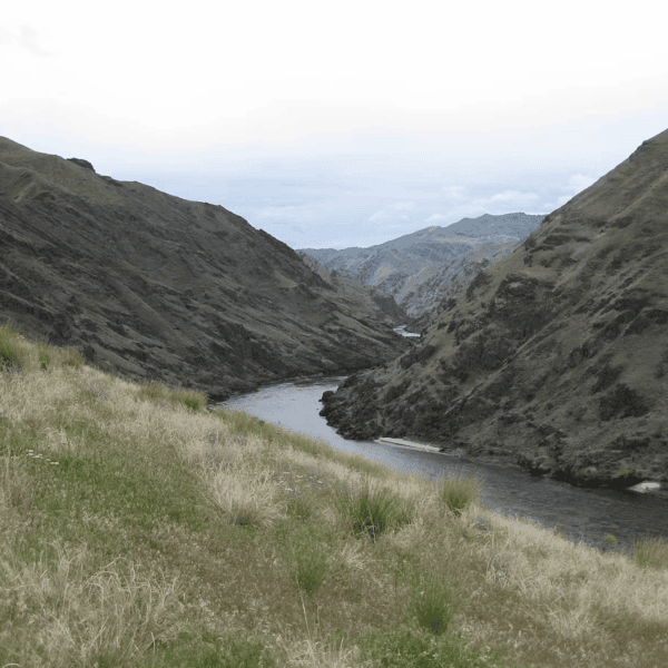
Wyoming Basin Shrub Steppe
The most intact arid grassland-shrub steppe in North America and the 4th most intact in the world.
Spanning five states, this beautiful rolling sagebrush steppe is home to the continent’s largest populations of sage grouse and pronghorn. Wyoming Basin Shrub Steppe's grasses and shrubs also support the longest mule deer migration. This intact range is still wild enough to host huge herds of elk, as well as bears and bison. Photo: Tom Koerner, USFWS.
These U.S. grasslands are still at least 50% intact:
Click photo to read about each grassland.

Flint Hills Tallgrass Prairie

Montana Valley and Foothill Grasslands

Northern Shortgrass Prairie

Western Shortgrass Prairie
Flint Hills Tallgrass Prairie
Kansas and Oklahoma
The Flint Hills of Kansas and northern Oklahoma are celebrated as one of the last great strongholds of tallgrass prairie in the world. This region is renowned for its sweeping grassland vistas, dramatic ridgelines, and deeply rooted cultural history tied to ranching and the use of prescribed fire at large scales. Unlike much of the tallgrass prairie that has been lost to row crop agriculture, the Flint Hills remain largely unplowed thanks to their rocky soils and steep hillsides—preserving a globally rare ecosystem that once covered vast portions of the central United States.
This landscape is home to a diverse array of iconic wildlife and natural features that attract visitors and scientists alike. Records as far back as the 1800s mention the use first use of the term “Flint Hills” along with American bison (or buffalo), pronghorn antelope, deer, elk and panthers that early U.S. explorers came across.American bison can be found in herds in places like the Tallgrass Prairie National Preserve, while greater prairie-chickens gather on spring leks. The Flint Hills also boast a stunning diversity of wildflowers, particularly in late spring and early summer, creating a breathtaking landscape of vibrant colors.
The Flint Hills experiences the full suite of climate dynamics, with extreme hot and cold temperatures within a single year, droughts and rainfall deluges, and over 200 days of clear skies per year. This region exudes a sense of timelessness, where ranching traditions persist, grassland fires shape the ecosystem, and visitors can immerse themselves in a rare and pristine piece of America’s natural heritage. Approximately 50% of this region remains largely intact. Photo: Greg M. Peters
Montana Valley and Foothill Grasslands
Idaho, Montana, Alberta
The Montana Valley and Foothill Grasslands ecoregion is a crucial transition zone where the Great Plains meet the Rocky Mountains. This unique landscape, sculpted by a history of grazing by bison and periodic wildfires, is characterized by rolling hills, river valleys, and a diverse array of plant life. The region is particularly famous for its spectacular scenery where the expansive grasslands dramatically give way to the rugged peaks of the Rockies.
This ecoregion is a haven for iconic wildlife species of the American West. While the large herds of American bison that once roamed here have been greatly diminished, smaller populations can still be found in the few remaining protected areas. Other charismatic fauna include elk, pronghorn, white-tailed and mule deer, and bighorn sheep. The area is also one of the last places in the United States where grizzly bears venture from the mountains onto the plains to forage. In addition, the region supports a rich birdlife, including large breeding populations of trumpeter swans and sandhill cranes in places like the Centennial Valley.
Ranchers in the area are often seen as the stewards of the land, with their practices playing a key role in the health of the ecosystem. Conservation organizations work with local ranchers to preserve the remaining grasslands and the species that depend on them, while also supporting the local rural economy. About 60% of the region is still in intact. Photo: USFWS
Northern Shortgrass Prairie
Montana, Wyoming, North Dakota, South Dakota, Nebraska, Saskatchewan, Alberta
The Northern Shortgrass Prairie spans 719,348 km2 across North America. This region is a crucial part of the Great Plains, stretching through five U.S. states—Montana, Wyoming, North Dakota, South Dakota, and Nebraska—and two Canadian provinces, Saskatchewan and Alberta. It is characterized by a harsh winter climate, with significant amounts of snowfall, and its short growing season, punctuated by periodic severe droughts.
These conditions have shaped the landscape and its dominant vegetation, which consists of short-statured, drought-resistant grasses like grama grasses and wheatgrass. The ecoregion's immense size and relatively high percentage of intact habitat make it a globally significant area for conservation, though it is considered "poorly protected" in terms of designated reserves or federally protected areas.
The ecoregion is an essential habitat for a suite of iconic wildlife species adapted to the open, arid plains such as the black-tailed prairie dog. The region also hosts large mammals such as pronghorn, bison (in some areas), and mule deer. It's also an important area for raptors species such as the ferruginous hawk and the burrowing owl. Unique to this region are specific grassland birds, including the mountain plover and Sprague's pipit, whose populations are heavily dependent on the shortgrass prairie.
The ranching identity and culture in the ecoregion are deeply tied to its geography and a history of working the land in challenging conditions. Given the harsh climate and short growing season, traditional dryland farming is less feasible in much of the area, making livestock grazing the primary and most sustainable land use.
Collaborative projects between ranchers and conservation organizations are becoming more common, aiming to balance agricultural practices with the needs of the ecosystem and its native species. This cooperative approach highlights a shared goal of preserving the integrity of this intact prairie region and its traditional way of life. About 50% of the ecoregion remains intact.
Photo: Brett Snyder, CC.
Western Shortgrass Prairie
Wyoming, Nebraska, Kansas, Colorado, Oklahoma, Texas, New Mexico
The Western Shortgrass Prairie, also known as the High Plains, is a major grassland ecoregion of the North American Great Plains, stretching from Texas and New Mexico in the south to Nebraska and Wyoming in the north. This ecoregion is distinguished by its semi-arid climate, lying in the rain shadow of the Rocky Mountains, and its vegetation is dominated by resilient, sod-forming perennial grasses like blue grama and buffalograss. The Western Shortgrass Prairie is a globally significant ecosystem due to its enormous size and relatively high degree of habitat intactness compared to other converted North American grasslands. However, it is poorly protected. This area was also the epicenter of the 1930s Dust Bowl, a historical event that highlights the delicate balance between land use and the region's climate.
The ecoregion is home to a unique assemblage of wildlife that has adapted to its harsh, arid conditions. While black-tailed prairie dogs are a vital keystone species whose colonies create microhabitats for many other animals, the region's open landscape is also crucial for large mammals such as pronghorn and mule deer, and several threatened grassland birds. For example, the mountain plover is a ground-nesting bird that relies on the ecoregion's short, sparse vegetation. Other characteristic bird species in the ecoregion include the burrowing owl, scaled quail (mostly in the south), and various sparrows and hawks.
Livestock grazing remains the most sustainable economic activity for most ranchers in the region, despite the challenging environment. Frequent droughts, extreme weather events, conifer encroachment, and invasive annual grasses (IAGs) are challenges that ranchers and land managers often face in this environment. Despite these challenges, ranchers are key partners in conservation and often lead the charge, alongside conservation groups, to implement durable conservation solutions. About 50% of the ecoregion remains intact. Photo: Creative Commons
Other Notable U.S. Grasslands
Click a grassland name on the left side of screen to read about each grassland.
Snake-Columbia Steppe
Palouse Prairie
Great Basin Shrub Steppe
Central-Southern Mixed Grass Prairie
Northern Mixed Grass Prairie
Texas Blackland Prairie
California Central Valley Grasslands
Western Gulf Coast Grasslands
Northern Tallgrass Prairie
Central Tallgrass Prairie
Snake-Columbia Steppe
Idaho, Oregon, Washington, Nevada, California
 The Snake-Columbia Steppe is a vast shrub-steppe ecoregion covering a large portion of the interior Pacific Northwest. This region, encompassing areas of Washington, Oregon, Idaho, Nevada, and California, is defined by its arid to semi-arid climate and its location within the rain shadow of the Cascade Range. The landscape is a mosaic of sagebrush, perennial bunchgrasses such as bluebunch wheatgrass and Idaho fescue, and has volcanic features such as lava fields and isolated fault-block mountains. While significant parts of this ecoregion, particularly the Snake River Plain in Idaho, have been developed for agriculture and urban areas, a considerable amount of the original shrub-steppe remains, making it a critical area for conservation. However, the region's overall conservation status is challenged by a lack of protected areas and increasing threats from invasive species leading to altered fire regimes.
This ecoregion is a haven for wildlife adapted to the xeric conditions of the area. The greater sage-grouse, a species of global conservation concern and near threatened on the IUCN Red List, is considered a flagship species for the Snake-Columbia Steppe. Its survival is directly tied to the health of the declining sagebrush ecosystem. The region also supports other iconic species such as the pronghorn, North America's fastest land mammal, and the pygmy rabbit, the continent's smallest rabbit, which is heavily dependent on sagebrush for food and shelter.
Historically, ranching has been a major economic driver, with vast tracts of land used for grazing. The culture is one of rugged individualism and a deep knowledge of the land's unique ecology. However, modern challenges, particularly the spread of invasive annual grasses, which fuel more frequent and intense wildfires, and juniper encroachment are threatening ranching and wildlife alike. Many ranchers working closely with conservation groups are implementing strategic conservation practices that help to maintain native grasses and sagebrush, thereby benefiting both livestock and wildlife species. More than 45% of this ecoregion remains intact. Photo: NPS
Palouse Prairie
Washington, Oregon, Idaho, British Columbia
The Palouse Prairie (aka the Columbia shrub steppe) is a unique and critically endangered ecosystem in the interior Pacific Northwest. This region, centered on southeastern Washington and parts of Idaho, Oregon and British Columbia, is famous for its distinctive rolling hills, which are formed by deep, fertile soils known as loess. Unlike many other North American grasslands, the Palouse has a more maritime-influenced climate with warm, dry summers and cool, wet winters, and a higher average precipitation than the surrounding shrub-steppe. Historically, this ecoregion was a "sea of grass" dominated by tall, perennial bunchgrasses like bluebunch wheatgrass and Idaho fescue, and a diverse array of wildflowers. However, due to extensive conversion for agriculture, not much of the original Palouse Prairie remains, making it one of the most at-risk ecosystems in the United States.
The Palouse Prairie once supported a rich variety of wildlife, though the historical lack of large bison herds distinguishes it from the Great Plains. The region's animals were adapted to the lush, bunchgrass habitat and included large mammals such as mule deer, white-tailed deer, and a variety of small mammals such as ground squirrels, gophers, and small rodents such as voles. These smaller animals were, in turn, preyed upon by badgers, coyotes, hawks, and owls. Historically, the area was also home to ground-nesting birds like the sharp-tailed grouse, which are a species of concern in the region due to habitat loss and competition from introduced species.
The Palouse Prairie's history and culture are inextricably linked to its deep, fertile soils. Unlike the arid lands of the surrounding shrub-steppe where ranching has been the primary land use, the Palouse was almost entirely converted to tillage agriculture, primarily for wheat and legumes. The unique loess hills posed challenges for early farmers, but modern technology has allowed for cultivation on steep slopes.
Today, conservation groups and landowners are collaborating to restore remnants of the prairie in small patches, alongside fields, and in areas that are too steep to farm. Conservation goals include providing habitat for remaining species and to support native pollinators and other wildlife and reflect a growing awareness of the need to balance the region's strong agricultural heritage with the preservation of its native ecosystem. About 45% of this ecoregion remains intact. Photo: Lynn Suckow, USFS
Great Basin Shrub Steppe
California, Nevada, Utah, Idaho, Oregon

The Great Basin Shrub Steppe is one of North America's largest and most remote ecoregions. Encompassing most of Nevada and Utah, and parts of Oregon, California and Idaho, this vast and arid region is a series of uplifted, fault-block mountain ranges separated by wide, internally drained basins. The climate is characterized by hot summers and cold winters averaging 10 inches of annual precipitation. The dominant vegetation is sagebrush and salt-desert scrub, along with perennial grasses like bluebunch wheatgrass and Sandberg bluegrass. This ecoregion is part of the larger Great Basin Desert and is bounded by the Sierra Nevada to the west and the Wasatch Mountains to the east. Historically, it was characterized by infrequent, low-intensity fires, but this fire regime has been significantly altered by the introduction of invasive species like cheatgrass and expansion of pinyon-juniper woodlands.
The Great Basin Shrub Steppe is a critical habitat for a variety of iconic wildlife species adapted to its arid conditions. The region is essential for the survival of the greater sage-grouse, a species of global conservation concern. Other characteristic mammals include pronghorn, mule deer, bighorn sheep, and pygmy rabbit. The area also hosts a diverse population of small mammals, such as kangaroo rats and ground squirrels, and is home to a wide array of reptiles and raptors, including the prairie falcon.
Culturally, livestock ranching became a major economic driver following European settlement. While over 80% of the ecoregion is publicly owned (federal and state), ranchers settled the best-watered lands making most mesic areas privately owned. Ranchers work closely with federal land managers and conservation groups to sustain grazing and wildlife values, while combating shared threats like invasive species and altered fire regimes. This collaborative approach highlights a growing recognition of the role that ranching can play in preserving the ecoregion's unique ecosystem and traditional way of life. About 30% of this ecoregion remains intact. Photo courtesy of Little Wild production.
Central-Southern Mixed Grass Prairie
Nebraska, Kansas, Oklahoma, Texas

The Central-Southern Mixed Grass Prairie is an expansive ecoregion functioning as an ecological transition zone between the wetter Tallgrass Prairies to the east and the drier Shortgrass Prairies to the west.
This ecoregion stretches from southern South Dakota, through Nebraska, Kansas, and Oklahoma, and down into the Rolling Plains of Texas. The landscape is characterized by a mix of rolling hills and loessal plains, and its defining feature is a blend of tall, mid, and short grasses. Prior to vast of the region to cropland in the wake of European settlement in the latter half of the 19th century, this region was a lush grassland, as illustrated in a quote from Hattie Gibbons in 1876 when her and her husband homesteaded in the Ninnescah Valley east of present-day Pratt, KS: “The prairie was covered with a green carpet of grass, and here and there in the low places the flowers bloomed all summer long … I lived in a vast garden and in between the beds were long avenues of (green) stretching away to the horizon … I felt relaxed and had a sense of freedom.”
The vegetation is a mosaic of species from both the tallgrass and shortgrass prairies, with species like little bluestem and side-oats grama mixing with blue grama and buffalograss, reflecting its transitional nature and the varied soil moisture and topography. Today, this ecoregion maintains “blocks or tracts” of prairies within a larger landscape. This is highly evident in areas such as the Gypsum Hills and Smoky Hills, where these “blocks” of grassland lies within “blocks” of farming.
This ecoregion provides critical habitat for a variety of iconic wildlife species, particularly for grassland birds. The lesser prairie-chicken, a species of significant conservation concern and vulnerable on the IUCN Red List, is a flagship species of this region. Other mammal species such as white-tailed jackrabbits were once prominent in the ecoregion. However, both jackrabbits and lesser-prairie chicken population have experienced substantial declines due to habitat loss and grassland fragmentation. Other notable wildlife includes prairie dogs, pronghorn, mule deer, and a variety of raptors. The region's wetlands, such as Cheyenne Bottoms and Quivira National Wildlife Refuge in Kansas, are also globally important stopover points for migratory waterfowl and shorebirds, highlighting the ecoregion's value to a broader, continental ecosystem.
The culture and identity of the ecoregion are a unique blend of farming and ranching. Cattle drives through vast grassland along key trails, such as the Chisholm Trail, gave way to a fragmented landscape where large portions of the ecoregion have been converted to agriculture, particularly in areas with deeper, more fertile soils. However, many conservation efforts, much like in the Flint Hills, are rooted deeply in working with private landowners to manage their land in ways that are both economically viable and beneficial for wildlife. Much of the region also holds a rich, large scale prescribed fire heritage. This collaborative approach recognizes the vital role that private lands play in conservation and preserves a traditional way of life while also ensuring the long-term health of the ecosystem. Only about ~25% remains intact. Photo: Jeremy Roberts, Conservation Media
Northern Mixed Grass Prairie
North Dakota, South Dakota, Montana, Minnesota, Saskatchewan, Manitoba

The Northern Mixed Grass Prairie stretches across 219,000 km2, spanning parts of Montana, North Dakota, South Dakota, and Minnesota, as well as southern Saskatchewan and Manitoba.
Sitting between the drier Shortgrass Prairie to the west and the wetter Tallgrass Prairie to the east, it bridges two major ecosystems. The region receives 250–650 mm of precipitation annually, mostly from April to June, and experiences hot summers (15–25 °C) and cold winters (–16 to –5 °C). Soils range from Entisols in the west to rich Mollisols in the east, with claypan or hardpan layers that affect drainage. The growing season runs from April to early September.
At the heart of this landscape lies the Prairie Pothole Region—a network of thousands of shallow, glacially formed wetlands that provide crucial habitat for waterfowl and migratory birds. Although the potholes make up only about 10% of North America’s breeding habitat, they produce roughly half of the continent’s ducks and support some of the highest densities of breeding pairs found anywhere.
The prairie itself blends tall, mid, and short grasses, including both cool- and warm-season species. Native plants such as needle-and-thread, western wheatgrass, and little bluestem dominate, though invasive grasses like Kentucky bluegrass and smooth brome have spread widely, altering soil and water cycles. Other invaders include crested wheatgrass, reed canarygrass, and cattails.
Wildlife thrives here, from moose, pronghorn, and mule deer to prairie dogs and burrowing owls. Over 140 bird species breed in the region, including Baird’s sparrow, Sprague’s pipit, and the chestnut-collared longspur. The prairie also supports pollinators like monarch butterflies, regal fritillaries, Dakota skippers, and native bees, all dependent on the region’s diverse grasses and wildflowers.
Historically maintained by bison and periodic wildfires, today’s prairies are largely shaped by cattle grazing. Rotational and twice-over grazing systems help mimic natural cycles. With only about 10% of the original prairie remaining, partnerships between ranchers and conservationists are key to protecting these grasslands—and the wildlife, pollinators, and people who depend on them. Photo: NPS
Texas Blackland Prairie
Texas
 The Texas Blackland Prairie is one of the most imperiled ecosystems in North America. The ecoregion is comprised of two prairies separated in the middle by a Post Oak Savanah. The larger prairie runs in a narrow, crescent-shaped belt through east-central Texas, from just south of the Red River to near San Antonio. The smaller prairie, commonly referred to as the Fayette Prairie, lies southeast of the main prairie and primarily occupies current day Washington, Fayette, Lavaca, and Dewitt counties. It is named for its deep, fertile, black alkaline clay soils, often referred to as "black gumbo," which are among the richest soils in the world. Additionally, the ecoregion is home to Vertisol soils that undergo significant shrinking and swelling with changes in soil moisture, creating pockets of unique microclimates and geologic features such as gilgai.
Historically, this region was a tallgrass prairie dominated by species such as big bluestem, little bluestem, Indiangrass, and switchgrass, all maintained by the combined effects of periodic fires and grazing by bison. However, due to its exceptional fertility, most of the original prairie has been converted to agriculture, making it one of the most heavily altered ecoregions globally.
As with most of the Great Plains, the most prominent large grazer was the American bison. However, other wildlife such as white-tailed deer and a variety of small mammals can be found here today. The prairie also once supported a diverse array of grassland birds, including the iconic Bobwhite quail, but these species have been severely impacted by habitat loss and fragmentation. Today, the few remaining patches of prairie provide habitat for a much-reduced suite of wildlife.
The fertile black soils drew early settlers to the region, who quickly recognized the land's potential for farming. As a result, the region became a major center for cotton, corn, and wheat production. Exotic pasture grasses such as King Ranch bluestem, bermudagrass, and Johnsongrass were also heavily introduced throughout the region, displacing native grasses. This intensive agricultural history has created a culture centered on farming, and today, the region's economy is still largely based on cropland and livestock grazing. However, with the rapid urban expansion of major metropolitan areas like Dallas, Austin, and San Antonio into the ecoregion, the remaining natural and semi-natural lands face new pressures. Conservation efforts in the ecoregion today are largely focused on ecological restoration, trying to re-establish native grasses and managing the small, fragmented remnants of the once-vast prairie. Only about 10% remains intact. Photo courtesy of Partnerscapes.
California Central Valley Grasslands
California
 The California Central Valley Grasslands are defined by their Mediterranean climate, with hot, dry summers and cool, wet winters. Historically, the valley floor was a diverse mosaic of perennial bunchgrasses, including species of needlegrass, along with wetlands, riparian forests, and seasonal vernal pools. However, this ecoregion has been drastically transformed by human activity. Extensive agricultural development and urban expansion have led to the loss of over 90% of its natural wetlands and the widespread dominance of non-native annual grasses.
Despite this transformation, the ecoregion still holds a place as a critical habitat for several unique and highly threatened wildlife species. The southern portion of the valley, a more arid desert grassland, is home to the critically endangered San Joaquin kit fox, as well as several species of kangaroo rats and the blunt-nosed leopard lizard. The remaining wetlands of the northern valley are still vital for millions of migratory waterfowl and shorebirds that use the “Pacific Flyway.” The region also supports the Tule Elk, a subspecies of elk found only in California that was nearly hunted to extinction.
The history of the ranching identity is deeply rooted in the state's Spanish and Mexican past. The introduction of cattle in the 1700s led to the establishment of vast "ranchos," which became the economic backbone of the state, fueled by the trade of hides and tallow. The discovery of gold in the mid-19th century further intensified the demand for beef, shifting the focus of ranching to meat production. Today, the ranching culture in the Central Valley has evolved, with many family-owned ranches still operating. There is a growing trend of collaboration between ranchers and conservation groups to preserve the ecoregion's unique and imperiled biodiversity. Less than 10% remains intact. Photo by Gary Morgret, Courtesy of the California Native Grasslands Association.
Western Gulf Coastal Grasslands
Louisiana, Texas, Mexico

The Western Gulf Coastal Grasslands form a distinctive subtropical ecoregion stretching along the Gulf of Mexico from southwestern Louisiana through coastal Texas into northeastern Tamaulipas, Mexico. Part of the North American Coastal Plain—a global biodiversity hotspot—this landscape features flat to gently rolling terrain and a mosaic of habitats including coastal prairies, estuarine marshes, and barrier islands. In the south, vast Quaternary sand deposits create the Coastal Sand Plains, a unique area of dunes and swales that differ from nearby brushlands.
The climate is humid subtropical, becoming drier westward, and supports a mix of tall coastal grasses like seacoast bluestem and gulf dune paspalum, along with inland prairies dominated by little bluestem, big bluestem, and brownseed paspalum. Much of the original prairie has been converted to cropland, rice fields, or urban areas. Invasive woody plants such as Chinese tallow and Macartney rose, combined with reduced fire frequency, have further diminished native grassland diversity.
This ecoregion is home to several rare and endangered species, most notably the Attwater’s prairie-chicken, a critically imperiled bird found only in these coastal prairies. The area also lies within the Central and Mississippi Flyways, providing crucial wintering and stopover habitat for countless migratory birds, including the endangered whooping crane. Coastal wetlands sustain diverse waterfowl and shorebirds, while remaining prairies harbor over 400 species of native plants. Isolated remnants support rare and endemic flora such as the black lace cactus and salt prairie paintbrush. Pocket gophers across the region act as ecosystem engineers, enriching soils and creating habitat variation.
The identity and culture of the region are deeply tied to its land and history. Ranching, rice, and cotton farming have long defined its economy, shaping a culture of cattlemen and farmers adapted to the coastal landscape. Today, less than 10% of the original grassland remains. Conservation groups, ranchers, and private landowners are increasingly working together to restore prairies and wetlands, aiming to preserve the region’s rich biodiversity while maintaining its agricultural heritage and coastal resilience.
Photo: William L. Farr, CC.
Northern Tallgrass Prairie
 North Dakota, Minnesota, Iowa, Manitoba
The Northern Tallgrass Prairie covers about 76,000 km2 from southern Manitoba through eastern North Dakota and western Minnesota to northwestern Iowa. Known for its deep, fertile soils—built over millennia by glaciers and the decay of prairie plants—this region once supported vast expanses of tall, lush grasslands. Elevations range from 229 to 610 meters, and the climate is temperate and continental, with hot summers (15–25 °C), cold winters (–16 to –5 °C), and most precipitation (560–650 mm annually) falling between April and June.
The prairie’s rich Mollisol soils, composed mainly of silt and clay loams, support an extraordinary diversity of plant life. Towering grasses like big bluestem, Indiangrass, and switchgrass can grow over 1.8 m tall, with roots extending more than 3 m deep. Among them thrive vibrant wildflowers—coneflowers, blazing stars, milkweeds, and clovers—that once painted the landscape with seasonal color.
This ecosystem evolved under a rhythm of grazing, fire, and climate variability. Bison were the dominant grazers, shaping vegetation through their migrations and foraging. Elk, deer, and smaller animals added further disturbance through trampling and burrowing. Fire, occurring naturally or set by Indigenous peoples every one to five years, prevented trees and shrubs from taking hold and maintained the prairie’s open structure. Periodic droughts reinforced resilience and adaptation among the native plants and wildlife.
The region’s wildlife today includes iconic grassland birds and pollinators such as monarch butterflies, regal fritillaries, and Dakota skippers. Many of these species rely on specific native plants—monarchs on milkweed, fritillaries on violets—and need large, connected tracts of grassland for feeding, breeding, and migration. Grassland birds like the bobolink and Henslow’s sparrow, once abundant, now face steep declines due to habitat loss.
The prairie’s deep, black soils have long shaped the region’s identity and economy. European settlers transformed it into one of the world’s most productive agricultural zones, converting over 99% of its native grasslands to cropland.
Today, less than 5% remains intact. Conservation now focuses on restoring prairie remnants, protecting pollinators, and promoting sustainable agriculture to preserve the soil, water, and heritage that define the Northern Tallgrass Prairie. Photo: Beverly Meyer, USFWS.
Central Tallgrass Prairie
Minnesota, Nebraska, Kansas, Iowa, Indiana, Illinois, Wisconsin
The Central Tallgrass Prairie, often referred to as the heart of the tallgrass prairie, stretches from eastern Kansas and Nebraska to Illinois and Indiana, and north into parts of Wisconsin and Minnesota. It is distinguished by a mesic climate, with the highest rainfall and deepest soils within the Great Plains. These deep, rich "Mollisols" were formed over thousands of years and are the key to the ecoregion's historical lushness, with grasses like big bluestem, Indiangrass, and switchgrass often growing to over two meters tall. This combination of fertile soil and abundant moisture also made the Central Tallgrass Prairie the most suitable region for row-crop agriculture, leading to its dramatic conversion. It is now one of the most converted ecoregions in the world, and the least intact in North America.
The Central Tallgrass Prairie once supported a vast and diverse suite of wildlife as it was a prime grazing ground for large mammals, with elk and bison playing a crucial role in maintaining the prairie ecosystem. However, the most distinctive wildlife today are the grassland birds such as upland sandpiper, and Henslow's sparrow. Many of these species are facing significant population declines due to habitat loss and fragmentation. While the charismatic megafauna are largely gone, smaller animals like the plains pocket gopher, prairie vole, and ornate box turtle are still found in remnant prairies, and the ecoregion is an important migratory pathway for insects like the monarch butterfly.
The fertile black soils, which were ideal for tallgrasses, were also perfect for farming, leading to a near-total conversion of the landscape. Early settlers, often referred to as "sodbusters," used new steel plows to break through the dense root systems of the prairie grasses, transforming the land into the most productive agricultural region in the United States, known as the "Corn Belt."
Today, the culture is deeply rooted in this farming heritage, with many communities and economies centered on corn and soybean production. Despite the near-complete loss of the original prairie, there is a growing movement to conserve what little is left. Multiple conservation efforts are working to reintroduce bison and use controlled burns and grazing to mimic natural processes, highlighting a growing recognition of the need to balance the region's agricultural identity with the preservation of its unique ecological heritage. Photo: By cassi saari - Own work, CC BY-SA 4.0,
Biomes in Peril
Our planet has already lost more than half of its vital grasslands—and the other half is at risk. Grasslands provide people with abundant water, fertile soils, and prime livestock grazing land.
America’s Great Plains and sagebrush country are home some of the last, best grasslands in the world.
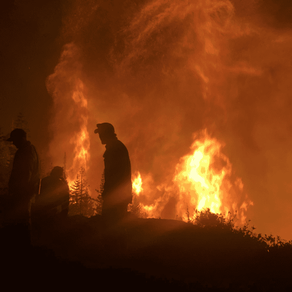
Sadly, much of the original Great Plains grasslands have been plowed under for crops, replaced with roads and homes, or taken over by encroaching trees like eastern redcedar. Five of the top 10 most converted temperate grasslands in the world are in the United States.
Farther west, threats like invasive annual grasses, encroaching trees, and crop conversion have impacted millions of acres of once-prime sagebrush range.
We’ve already lost too many acres of temperate and arid grasslands. And each year, we lose even more - 1.3 million acres of core sagebrush habitat and 2 million acres of Great Plains grasslands.
It’s time to take action to protect our last, great prairies.


What We Stand To Lose
If we don’t save what remains of our beautiful grasslands, the loss will resonate throughout our economy and culture. Large expanses of intact grasslands give us:

Ranching Profitability

Grassland Birds
Wildfire Resiliency

Water

Livestock Grazing

Migratory Big Game

Soils

Recreation

“Even though we’ve lost many of our grasslands, expansive areas still exist. These areas represent some of the best opportunities for large-scale, landowner-driven conservation efforts that contribute to global grassland conservation goals.”
Keeping Grasslands Productive and Profitable
Open rangelands are the backbone of the U.S. beef industry. More than 90 percent of America's Great Plains grasslands are privately owned, primarily by agricultural producers. In sagebrush country, much of the productive grassland is also privately owned. One of the best ways to conserve remaining grasslands is to support sustainable livestock grazing.
Working Lands for Wildlife, led by the USDA Natural Resources Conservation Service, provides ranchers with technical and financial assistance for voluntarily stewarding America’s grasslands. Our Frameworks for Conservation Action direct resources to landowners who tackle the main threats facing the Great Plains and sagebrush biomes.
We support the following conservation actions that boost profitability for ranchers and maintain intact grasslands:
- Prescribed fires
- Brush management or removal of encroaching trees
- Invasive annual grass treatments
- Grazing practices that conserve native plants

Meet The Ranchers Conserving America's Grasslands

Bill Browning, Landowner, Kansas
Bill Browning and his family are keeping the Flint Hills of Kansas healthy, open and tree-free.

Rex Schmidt, Rancher, Kansas
Rex Schmidt is transitioning cropland restored through the Conservation Reserve Program into profitable grazing lands.

Scott Stout, Rancher, Nebraska
Scott Stout is using prescribed fire to reinvigorate pastures and stop trees from taking over ranches in Nebraska.
“The grassland biome is disappearing fast. It’s time to give our prairies the attention they deserve so they can continue to support people and wildlife,.”
Special thanks to the following people who helped contribute to this post: Jesse Nippert, Ian Tater, Jeremy Maestas, Tanner Swank, William Rogers, David Rowley, Doug Spencer, Dusty Tacha, Shea Coons, Justin Clarke, Cami Dixon, Torre Hovick, Dillon Fogarty, Ashley Tanner, Evan Tanner, and Tate Lantz.