New Web-Based Tool Helps Save Sage Grouse From Fence Collisions
SGI’s interactive web app now features a map layer that helps land managers prioritize where to mark high-risk fences to protect birds. This user-friendly tool allows ranchers and partners to make the most difference for sage grouse across the range.

The Science of Sagebrush: Measuring the Resilience of Rangelands
July 11, 2016
Sagebrush Rangelands Help Maintain Water Availability
August 3, 2016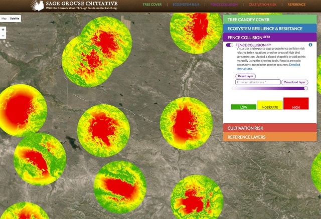
Photo: The new layer on SGI’s web app identifies areas with highest risk of fence collisions (red) within 1.8- mile radius circles around sage grouse mating leks.
SGI’s interactive web app now features a map layer that helps land managers prioritize where to mark fences to protect birds
Sage grouse tend to fly close to the ground, just skimming the tops of the sagebrush they use for cover, food, and rearing their young. Unfortunately, that means these iconic upland birds can get tangled in livestock fences, resulting in injury or fatalities.
The risk of striking fence wires is greatest when sage grouse are flying toward mating leks in the dim, pre-dawn light in the spring. A study in Idaho reported average collision rates as high as 1.2 strikes per mile of fence near leks each breeding season. It also found that 73% of strikes were within 0.3 miles of a lek, and 93% were within 0.93 miles.
Luckily, marking fences with simple vinyl strips can save the lives of sage grouse. These markers make the wires more visible to grouse and other large birds, and have been shown to reduce grouse collisions by up to 83 percent. Plus, they don’t disrupt agricultural practices.

Durable fence markers are typically cut from 3″ vinyl strips with reflective tape on both sides to increase visibility in low light. These are snapped onto the top wire at 3-foot intervals. (Photo Jeremy Roberts, Conservation Media)
Fence-marking is a key component of Sage Grouse Initiative’s conservation practices on working ranches. Since 2010, SGI has helped mark or remove 193 miles of “high-risk” fences on rangelands to improve habitat for low-flying grouse across 11 western states.
But not every mile of fence needs to be marked. To determine where to target money and resources, SGI scientists developed a mapping tool that prioritizes sites where sage grouse are most at risk of colliding with fences. The tool — based on a GIS model of strike-risk around 4,684 known leks — revealed that only 6 to 14 percent of the total sage grouse range pose a high risk for collisions if fences are present.
“We developed a model that explained these ‘hotspots’, then created a user-friendly tool to identify areas with higher and lower risk across landscapes,” says SGI researcher Bryan Stevens.

Low-flying sage grouse can strike unmarked fence wires, resulting in injuries or mortality. (Photo Jeremy Roberts, Conservation Media)
Now this tool is available to the public as a layer on SGI’s interactive web app. The fence collision layer visualizes and exports sage grouse collision risk relative to lek locations or other areas of high bird concentration. Users have to upload lek data or add points manually in order to calculate the risk at the local level. This step keeps sensitive lek information confidential to protect these important mating areas, and also allows land managers to tailor the tool to meet their needs. [Note: SGI does not archive or permanently store lek data.]
In addition to marking existing fences to improve visibility, the tool also helps partners and landowners identify where they might remove fences that are no longer needed and where to avoid building new fences. SGI has currently mapped high risk areas for grouse strikes (where there is likely to be more than one strike over the lekking season) across 10 states in sage grouse range.
“This tool puts data directly into the hands of the people working on the range. It helps prioritize conservation planning so we can put fence markers where they’ll make the most difference for birds on the landscape,” says Thad Heater, coordinator of the Sage Grouse Initiative.
Read SGI’s Science to Solutions article: Marking High-Risk Fences Saves Sage Grouse