Bird's eye view of the Warner Mountains landscape. Jeremy Roberts.
Publication Alert
New tool maps the likelihood of large wildfires in the Great Basin
Two new papers highlight how rangeland fires are different from forest fires and how fire-probability research can inform fuels management in rangelands.

Making Fences Friendlier for Ranchers and Wildlife
August 23, 2022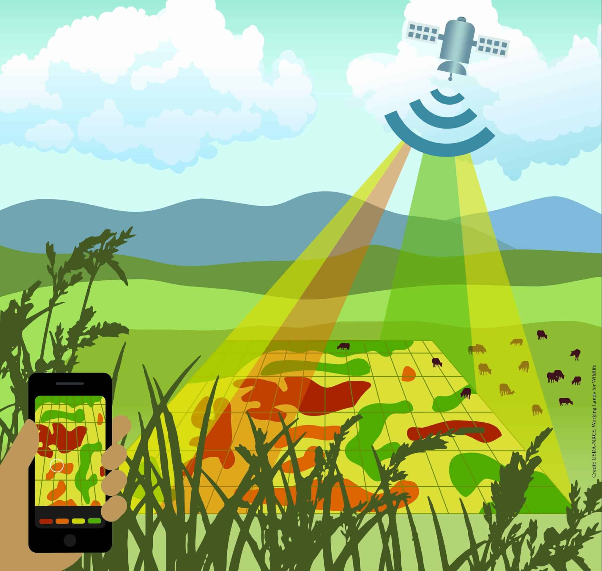
Next-gen remote sensing tools level up rangeland conservation
October 12, 2022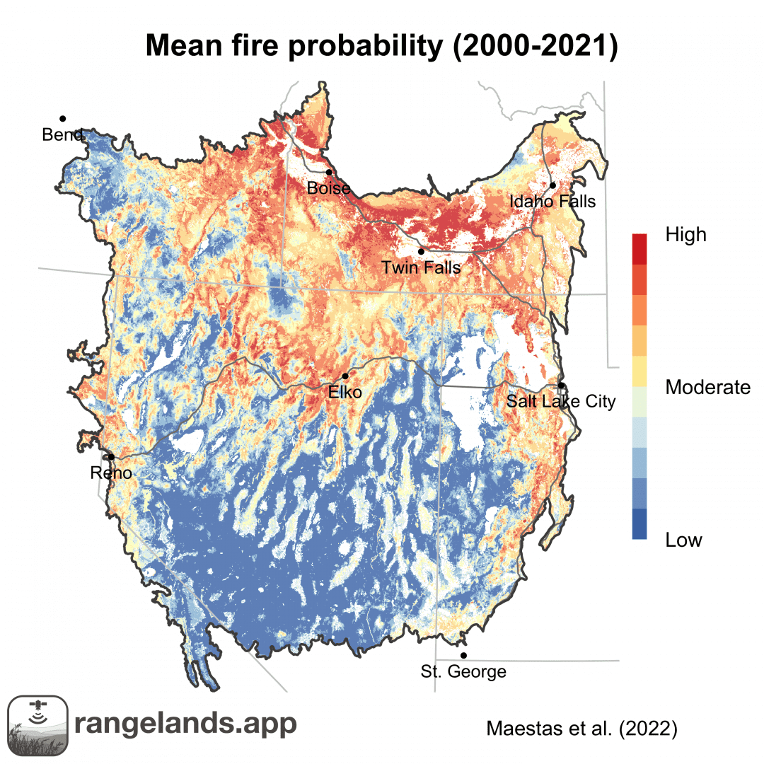

Forecasting fire probability for rangelands helps managers better prepare for rangeland fires.
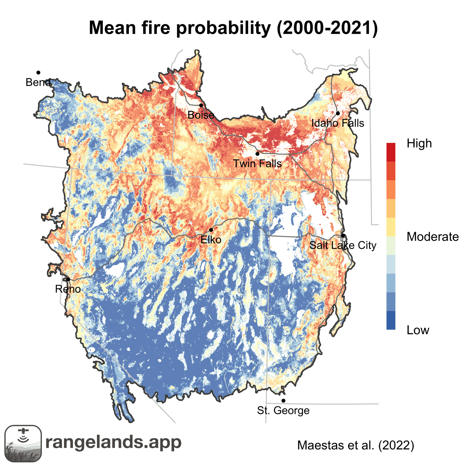
Wildfires are becoming more frequent and damaging in the arid West. Research, funded by the USDA’s Agricultural Research Service and supported by Working Lands for Wildlife (WLFW), provides a new tool to aid planners in predicting the probability of where large wildfires are likely to occur in the more than 60 million acres of the Great Basin.
Most fires are contained before causing widespread destruction. But, one to three percent of wildfires in the West escape containment to become large (more than 1,000 acres) and highly impactful, damaging sagebrush ecosystems, wildlife habitat, working ranches, and private property.
Predicting where these large wildfires could occur before fire season starts seems like magic, but when backed by science, this analysis is a key strategy that helps fire managers efficiently deploy fire-fighting resources and communities prepare for the fire season.
These forecasting tools have historically been focused on how fire behaves in a forested ecosystem. Forests have relatively stable sources of fuel (trees and forest-floor litter). As a result, moisture – or the lack thereof – has been a reliable predictor of fire risk. In other words, forests always have enough fuel for a wildfire, but monitoring if that fuel is dry enough to burn is crucial.
Predicting Rangeland Fire
Predicting wildfire in rangelands requires different considerations. Rangelands in the West are typically drier than forests, making predictions less related to moisture and more related to fuel quantity. Known as fuel-limited systems, the amount of burnable plant material in sagebrush rangelands varies considerably from year to year. In years with more fuel, wildfires are more likely to occur given an ignition.
Until this research, however, accurately measuring how much annual and perennial grasses and forbs were produced each year was difficult. Two complementary papers, published in the journal Rangeland Ecology and Management, detail how scientists are using the latest remote sensing technology to calculate the probability of wildfire risk based on vegetative data.
In the first paper, researcher Joe Smith from the University of Montana and colleagues used vegetation data from the Rangeland Analysis Platform alongside historical fire data from the Monitoring Trends in Burn Severity dataset to answer three fire-related questions for rangelands:
1. What kind of fire year might this be?
2. Where are fires likely to occur given an ignition?
3. What vegetation metrics are the best predictors of fire probability?
Smith and his team built fire-prediction models for the Great Basin using 32 years of historical weather, vegetation, and fire data. The team then used a ‘hindcasting’ approach to test their newly created models.
Their research highlights that herbaceous fuel loads – including both annual grasses and perennial vegetation – are the primary predictor of fire risk. They also determined that precipitation in previous growing seasons – rather than how wet or dry the current season is – is the most relevant driver of vegetation fuel loads, and therefore, fire risk in the Great Basin.
Smith’s team found fire risk is influenced equally by all herbaceous vegetation. However, the Great Basin has seen an alarming increase in invasive annual grasses that has mirrored an increase in the area burned in large rangeland fires.
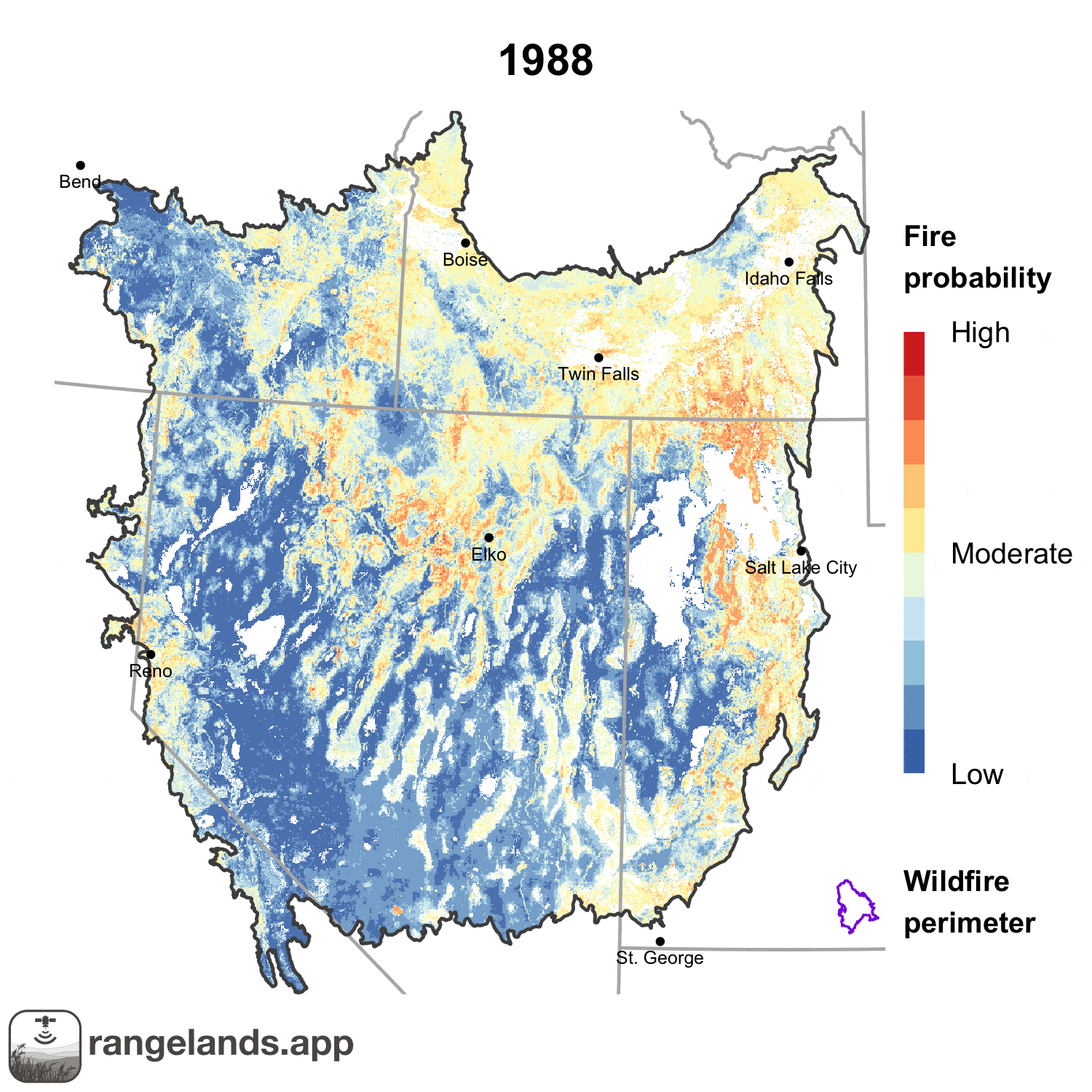
To share his research and provide managers with this much-needed information, Smith released updated fire-probability maps for the 2022 rangeland fire season in the spring, improving the ability of land managers to prepare for potential fires in the upcoming season (the paper was published in September 2022). The maps cover the five-state region of the Great Basin but can be scaled down to a county scale or even a single pasture. He plans to continue updating these maps annually.
Managing for Rangeland Fire
The second paper extends the fire probability work from analysis into how practitioners can use this information to make decisions for the fire season. Authored by Jeremy Maestas and others, the paper discusses rangeland fire trends revealed by Smith’s work, illustrates how Smith’s fire-prediction maps can be used by land managers to better prepare for rangeland fire, and provides current examples of how fire managers are shifting their focus regarding rangeland fuels management.
Maestas notes that, based on Smith’s research, fire probability is highly variable from year-to-year, emphasizing the need for flexibility in fire management across the Great Basin. Unlike weather and topography, managers can directly and preemptively manage available fuels. Smith’s work provides critical information for managers to prioritize preparedness and resources for the upcoming fire season.
Maestas highlights two key opportunities managers have when incorporating Smith’s fire-probability maps into management plans:
1. Pre-fire forecasting to enhance preparedness and suppression
2. Supporting the planning of targeted fine fuels reductions
Maestas suggests managers should incorporate Smith’s fire-prediction maps into other large-scale planning efforts that address rangeland health. For example, a recent effort launched in Oregon leveraged spatially derived vegetation cover data to create an integrated, cross-boundary strategy for tackling invasive annual grasses in the eastern part of the state. Integrating Smith’s fire-prediction maps would further inform management priorities by helping to target fuels reduction in areas where fire risk may be high.

Additionally, Smith’s research shows some regions in the Great Basin have a higher historical occurrence of fire. Integrating this data into large-scale fuels treatment plans, like herbicide applications or fuel breaks, can help managers better understand the tradeoffs when implementing such practices.
Other broad, biome-based planning and strategic efforts like the NRCS’s Working Lands for Wildlife’s Framework for Conservation Action in the Sagebrush Biome are also ripe for integration with Smith’s fire prediction maps. This effort specifically highlights invasive annual grasses as one of the major threats facing the sagebrush biome. On-the-ground efforts addressing cheatgrass that are supported through the framework can be better prioritized and targeted by incorporating Smith’s maps, thereby reducing both cheatgrass presence and potential fire risk.
This work highlights the crucial role of herbaceous fuels to fire risk, but land managers also recognize the significance of woody shrubs and trees like juniper or pinyon-pine. While these woody species do not increase the odds of a large fire occurring, shrubs burn hotter, causing more extreme fire behavior.
Combined, this research provides new insights into how managers can enhance their ability to put the right actions in the right places at the right times so they can reduce the risk of and impacts from large and severe wildfires in rangelands.
Find Smith’s Great Basin fire prediction maps here: https://rangelands.app/great-basin-fire/.
Where there’s smoke, there’s fuel: dynamic vegetation data improve predictions of wildfire hazard in the Great Basin
Abstract: Wildfires are a growing management concern in western US rangelands, where invasive annual grasses have altered fire regimes and contributed to an increased incidence of catastrophic large wildfires. Fire activity in arid, non-forested ecosystems is thought to be largely controlled by interannual variation in fuel amount, which in turn is controlled by antecedent weather. Thus, long-range forecasting of fire activity in rangelands should be feasible given annual estimates of fuel quantity.
Using a 32 yr time series of spatial data, we employed machine learning algorithms to predict the relative probability of large (>405 ha) wildfire in the Great Basin based on fine-scale annual and 16-day estimates of cover and production of vegetation functional groups, weather, and multitemporal scale drought indices. We evaluated the predictive utility of these models with a leave-one-year-out cross-validation, building spatial hindcasts of fire probability for each year that we compared against actual footprints of large wildfires. Herbaceous aboveground biomass production, bare ground cover, and long-term drought indices were the most important predictors of burning. Across 32 fire seasons, 88% of the area burned in large wildfires coincided with the upper 3 deciles of predicted fire probabilities. At the scale of the Great Basin, several metrics of fire activity were moderately to strongly correlated with average fire probability, including total area burned in large wildfires, number of large wildfires, and maximum fire size.
Our findings show that recent years of exceptional fire activity in the Great Basin were predictable based on antecedent weather-driven growth of fine fuels and reveal a significant increasing trend in fire probability over the last three decades driven by widespread changes in fine fuel characteristics.
Citation: Joseph T. Smith, Brady W. Allred, Chad S. Boyd, Kirk W. Davies, Matthew O. Jones, Andrew R. Kleinhesselink, Jeremy D. Maestas, David E. Naugle, “Where There’s Smoke, There’s Fuel: Dynamic Vegetation Data Improve Predictions of Wildfire Hazard in the Great Basin” Rangeland Ecology & Management, 2022, ISSN 1550-7424.
Permanent URL: https://doi.org/10.1016/j.rama.2022.07.005
Using dynamic, fuels-based fire probability maps to reduce large wildfires in the Great Basin
Abstract: Spatial and temporal dynamics of rangeland fuels is a primary factor driving large
wildfires. Yet, detailed information capturing variation in fine fuels has largely been missing from rangeland fire planning and fuels management. New fuels-based maps of Great Basin rangeland fire probability help bridge this gap by coupling dynamic vegetation cover and production data from the Rangeland Analysis Platform (RAP) with weather and climate data to provide annual forecasts of the relative probability of large wildfire.
In this paper, we review these new fuels-based maps and discuss implications for pre-fire planning, preparedness, and strategic fuels management. Examining patterns of fire probability through time reveals high spatial and temporal variation in risk of large wildfires across the Great Basin. Certain areas are chronically impacted with high fire probability most years, while others have more sporadic or low probability of large fire annually.
Maps confirm previous research that the recent increase in large fire risk in the region is highly associated with invasive annual grasses, but total aboveground herbaceous production (including perennials) continues to be a primary predictor of fire probability.
Fuels-based fire probability maps can be used alongside existing data sources and prioritization frameworks by fire and fuels managers to inform questions of 1) what kind of fire year might this be, 2) where large fires most likely to occur given an ignition, and 3) where resources should be focused.
We provide examples of how maps can be used to improve pre-fire preparedness and planning to enhance suppression, facilitate annual targeting of fine fuels reductions, and support land use planning for implementation of landscape-scale fuels management. Proactively incorporating this new information into rangeland fire and fuels management can help address altered fire regimes threatening the region’s wildlife and working lands.
Citation: Jeremy D. Maestas, Joseph T. Smith, Brady W. Allred, David E. Naugle, Matthew O. Jones, Casey O’Connor, Chad S. Boyd, Kirk W. Davies, Michele R. Crist, Andrew C. Olsen,
“Using Dynamic, Fuels-Based Fire Probability Maps to Reduce Large Wildfires in the Great Basin”
Rangeland Ecology & Management, 2022, ISSN 1550-7424.
Permanent URL: https://doi.org/10.1016/j.rama.2022.08.002