Publication Alert
Visual analysis shows tree expansion across Montana rangelands since 1950s
New mapping application shows where tree expansion is happening in Montana through easy-to-see, interactive comparisons of historical and modern aerial imagery.

2023 Western Working Lands for Wildlife Workshop Recap
July 27, 2023
WLFW Research Details How Wildfire Follows Cheatgrass In the Great Basin
September 29, 2023
Research enabled creation of mapping application that allows users to swipe between historical and modern aerial imagery to see tree expansion and other long-term landscape changes.
Tree encroachment happens when woody species move into tree-free ecosystems like sagebrush steppe or grasslands. When trees displace native grass and shrublands, they threaten numerous ecosystem services including wildlife habitat, forage production, water availability, carbon storage, and more.
But, because this landscape threat is slow-moving, it is hard to observe with the naked eye. New research from Scott Morford, a WLFW researcher at the University of Montana’s Numerical Terradynamic Simulation Group, combined machine learning with historic and modern aerial imagery to illustrate and analyze increasing tree encroachment in Montana over the past 70 years. His team then took that research a step further, developing a new visual tool that provides an instantaneous comparison between the 1950s and now.
Recent advances in remote sensing technologies have allowed scientists and range managers to better evaluate where trees are moving across the landscape and the impacts of that encroachment. However, this satellite-derived imagery is only available dating back to the mid-1980s – with some datasets only beginning in the 1990s – limiting these analyses to the past 30 years at best.
To overcome these limitations, Morford and his team acquired digitized historic aerial imagery sourced from the U.S. Geological Survey, which was collected by the U.S. Army from 1946-1977 (the median imagery date was 1954). They also sourced modern aerial imagery from the National Agricultural Inventory Program, which included imagery from 2019 and 2020.
Next, the team processed the imagery in a three-phase pipeline. First, they aligned and orthorectified (removed distortions or displacements) the historical imagery. Then, they modeled the tree cover for every pixel across all the images, both historical and modern. Finally, researchers analyzed the change in tree cover between the historical and modern imagery to produce estimates of tree-cover change from the mid-20th century to today.
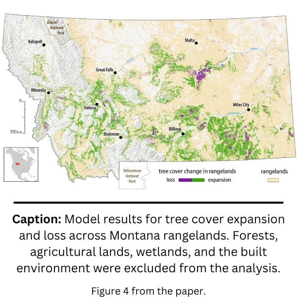
Because this analysis reached back decades further than other publicly available datasets, it quantified nearly twice as much tree cover expansion. The team found that across the nearly 48 million acres of Montana rangelands they analyzed, tree encroachment had occurred on approximately 7.4 million acres, or about 15.4% of intact rangelands in Montana. Additionally, most tree expansion occurred in grass or shrublands, as opposed to existing woodlands. The study highlights how tree encroachment is particularly threatening to Montana’s sagebrush ecosystems because they occupy the interface between forests and grasslands, increasing exposure of rangelands to tree seed sources.

Morford and his team used the processed imagery to build a new mapping platform where users can compare historical and modern imagery across 17 western states, called Landscape Explorer. A separate, Montana-specific mapping tool, provides the same opportunity to compare the past and present, while also highlighting where tree encroachment is currently threatening our sagebrush and grassland ecosystems.
This tool allows landowners, range managers, and the public to immediately see how Western landscapes have changed over the past 70 years. With a simple swipe, users can see trees move across the landscape, watch towns and cities grow and expand, and see other land-use changes that threaten our natural heritage.
This research adds to a growing body of science that highlights how tree expansion is one of the biggest threats facing western shrub and grasslands and how it is accelerating across the northern Great Plains. Addressing this threat is one of Working Lands for Wildlife’s key focus areas as detailed in the 2021 Frameworks for Conservation Action in the Sagebrush and Great Plains Biomes. Additionally, it helps prioritize where managers and landowners can enact proactive conservation strategies like “Defend the Core” that produce the best returns on conservation investments.

MAPPING TREE COVER EXPANSION IN MONTANA, U.S.A. RANGELANDS USING HIGH-RESOLUTION HISTORICAL AERIAL IMAGERY
Abstract: Worldwide, trees are colonizing rangelands with high conservation value. The introduction of trees into grasslands and shrublands causes large-scale changes in ecosystem structure and function, which have cascading impacts on ecosystem services, biodiversity, and agricultural economies.
Satellites are increasingly being used to track tree cover at continental to global scales, but these methods can only provide reliable estimates of change over recent decades. Given the slow pace of tree cover expansion, remote sensing techniques that can extend this historical record provide critical insights into the magnitude of environmental change.
Here, we estimate conifer expansion in rangelands of the northern Great Plains, United States, North America, using historical aerial imagery from the mid-20th century and modern aerial imagery. We analyzed 19.3 million hectares of rangelands in Montana, USA, using a convolutional neural network (U-Net architecture) and cloud computing to detect tree features and tree cover change.
Our bias-corrected results estimate 3.0 +- 0.2 million hectares of conifer tree cover expansion in Montana rangelands, which accounts for 15.4% of the total study area. Overall accuracy was [91%, but the producer’s accuracy was lower than the user’s accuracy (0.60 vs. 0.88) for areas of tree cover expansion. Nonetheless, the omission errors were not spatially clustered, suggesting that the method is reliable for identifying the regions of Montana where substantial tree expansion has occurred.
Using the model results in conjunction with historical and modern imagery allows for effective communication of the scale of tree expansion while overcoming the recency effect caused by shifting environmental baselines.
Citation: Morford, S.L., Allred, B.W., Jensen, E.R., Maestas, J.D., Mueller, K.R., Pacholski, C.L., Smith, J.T., Tack, J.D., Tackett, K.N. and Naugle, D.E. (2023), Mapping tree cover expansion in Montana, U.S.A. rangelands using high-resolution historical aerial imagery. Remote Sensing in Ecology and Conservation.
Permanent URL: https://doi.org/10.1002/rse2.357
Acknowledgment:This work was made possible by the USDA Natural Resources Conservation Service’s (NRCS) Conservation Collaboration Grant (Agreement NR200325XXXXC002). NVIDIA provided hardware used in this analysis through their Academic Hardware Grants program. The findings and conclusions in the publication are those of the authors and should not be construed to represent the views of the USDA, U.S. Fish and Wildlife Service, or the U.S. Government. Any use of trade, firm, or product names is for descriptive purposes only and does not imply endorsement by the U.S. Government.


