Publication Alert
America’s Tree Canopy, Now in 3D
Mapping application models height of trees and shrubs across the entire Lower 48 at sub-meter resolution.
Introducing The Mesic Analysis Platform: Restore Water Where It Matters Most
July 15, 2026
Guardians Of The Grasslands: The Ranchers Saving America’s Great Plains
August 12, 2026
FOR THE FIRST TIME, A SINGLE OPEN-ACCESS DATASET MAPS THE HEIGHT AND STRUCTURE OF INDIVIDUAL TREES AND SHRUBS ACROSS THE ENTIRE LOWER 48
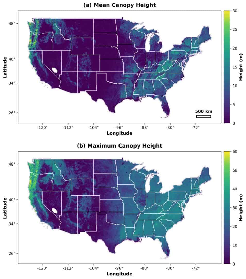
Researchers from the University of Montana and Working Lands for Wildlife have released a new open-access dataset that maps vegetation structure at sub-meter resolution across the contiguous United States.
Led by Scott Morford, the project was developed in collaboration with scientists from the USDA Agricultural Research Service and the New Mexico Consortium. The dataset and methods were published in the journal Scientific Data.
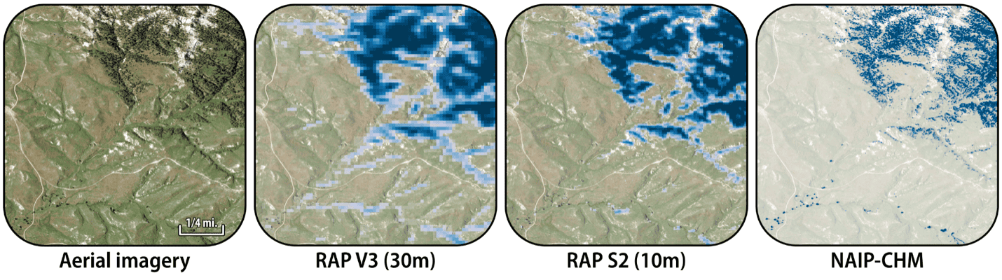
Designed to complement the Rangeland Analysis Platform (RAP), NAIP-CHM adds vegetation height and structure to the cover and production maps already used by land managers across the West.
For the last decade, RAP has transformed how scientists and managers monitor rangelands, extending field-scale insights across millions of acres and decades of change. But cover and production are fundamentally two-dimensional measures. NAIP-CHM adds the third dimension, revealing not just how much vegetation exists, but how it is vertically organized across the landscape.
That information is critical for land management and ecological research. In rangelands, where encroaching trees are a major driver of sagebrush and grassland loss, vegetation height helps managers prioritize treatments, estimate costs, and anticipate outcomes. The dataset is also relevant for wildfire, wildlife habitat, forestry, water, and woodland health applications.
NAIP-CHM is the first nationwide dataset to provide vegetation structure mapping at sub-meter (0.6 m) resolution, enabling individual tree and shrub detection across the contiguous United States. Recent global canopy height models from Meta (1 m) and ETH Zürich (10 m) have advanced large-scale vegetation mapping, but NAIP-CHM is the first to resolve individual shrubs and small trees at national scale — critical for rangeland and dryland ecosystems where vegetation is short, sparse, and structurally complex. The model was built from NAIP aerial imagery and trained on millions of lidar-derived examples collected across the United States.
The current release represents a national snapshot built primarily from 2022–2023 imagery. The University of Montana team also provides a cloud-based tool that allows users to generate structure maps for other years, with plans to expand the public dataset over time.
The team designed NAIP-CHM to make vegetation structure data as accessible as traditional satellite-derived cover products. National data are available for download from University of Montana servers, and an interactive map lets users explore the data directly.
Because it captures real, physical structure at fine scale, NAIP-CHM supports a wide range of applications, including:
- Woody encroachment monitoring in sagebrush and grasslands
- Woodland dieback and drought vulnerability assessment
- Wildfire fuels mapping and fire-behavior modeling
- Infrastructure and WUI risk assessment
- Wildlife habitat and migration analysis
- Forestry management and monitoring
- Water-use and water-yield modeling
- Dust-risk assessment
NAIP-CHM is more than a new map—it is a foundation for the next generation of rangeland, woodland, and forest monitoring tools. Working Lands for Wildlife scientists are developing applications that translate vegetation structure into on-the-ground decisions, helping target conservation and restoration investments to the places and treatments most likely to pay off. NAIP-CHM is part of a family of WLFW-developed conservation tools, including Landscape Explorer, Yield Gap in Rangeland Production tool, Invasion Severity Index, Early Warning for Woody Transitions, and the Mesic Analysis Platform, among others.
A 0.6-METER RESOLUTION CANOPY HEIGHT AND STRUCTURE MODEL FOR THE CONTIGUOUS UNITED STATES
Abstract: Above-ground vertical structure is a critical variable for ecosystem monitoring, carbon accounting, and land management. However, the high cost and limited coverage of airborne lidar hinder its widespread application. To address this, we developed NAIP-CHM, a 0.6-meter resolution canopy height and structure model (CHM) covering the contiguous United States, derived from National Agriculture Imagery Program (NAIP) aerial imagery. Unlike forestry-specific models that exclude human-made features, NAIP-CHM characterizes the full vertical structure of the landscape including vegetation, buildings, and infrastructure. We utilized a U-Net convolutional neural network with attention mechanisms and environmental conditioning, training and validating the model with a peer-reviewed, publicly available dataset of 22.8 million co-registered NAIP imagery and lidar-derived CHM pairs, with stratified sampling to ensure robustness in open-canopy ecosystems. The model achieved a pixel-wise root mean square error (RMSE) of 2.28 meters and an r2 of 0.87. Forested sites alone produced an r2 of 0.82 and RMSE of 3.82 meters. We provide the dataset, source code, and cloud-based tools to enable broad application without requiring specialized computational resources.
Citation: Morford, S. L., Allred, B. W., Coons, S. P., Marcozzi, A. A., McCord, S. E., Smith, J. T., & Naugle, D. E., A 0.6-meter resolution canopy height model for the contiguous United States. Sci Data (2026).
Acknowledgements: We thank Kris Mueller for assistance in figure preparation. This research used compute resources provided by (1) the SCINet project and/or the AI Center of Excellence of the USDA Agricultural Research Service (ARS project numbers 0201-88888-003-000D and 0201-88888-002-000D); (2) Google Earth Engine; (3) the Numerical Terradynamic Simulation Group at the University of Montana; and (4) the University of Montana’s Hellgate Research Cluster. Funding for this project was provided by USDA-NRCS (NR230325XXXXC009 to S.L.M.); Pheasants Forever (WLFW C008-2025-02 to D.E.N. and S.L.M.); and the DoD SERDP (RC20-1025, “Closing Gaps”) and ESTCP (RC23-7626, “FastFuels Tool Suite”) projects to A.A.M. Any use of trade, firm, or product names is for descriptive purposes only and does not imply endorsement by the U.S. Government.
Permanent URL: https://doi.org/10.1038/s41597-026-07549-w